 Photos By Date
| Hiking in Tierra del Fuego | 1 | 2 |
Click on a thumbnail to enlarge the picture. When viewing the full-size pictures, you can also view the remaining pictures "slideshow-style" by clicking on the "Prev" or "Next" buttons.
Note: For more information about these pictures, read about our experiences while hiking in Tierra del Fuego.
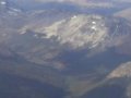 |
Over Tierra del Fuego — Flying over the majestic mountains of Tierra del Fuego ("Land of Fire"). They look pretty low for mountains...and they are: the highest point is barely over 1100 meters. |
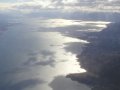 |
Over the Beagle Channel — Between the mainland and the rest of Tierra del Fuego is the Beagle Channel, named for Darwin's ship, which was neither the first, nor the last, nor the biggest, nor the most famous ship to pass through. But it sounded better than most of the alternatives. |
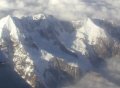 |
Not Tierra del Fuego — Actually, these are the Andes. We flew over them four days earlier flying from La Paz to Buenos Aires. But they looked cool, and we couldn't find anywhere else to put them. Besides, this is also what we thought Tierra del Fuego would look like, so to that extent, we feel justified in putting it here. |
 |
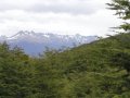
Beagle Channel — A glimpse of the channel from Pampa Alta, the peak of our hike through Tierra del Fuego National Park. |
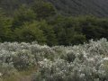 |
Cañadón del Toro — View of the 970-meter peak over the Pipo River Valley from Pampa Alta. |
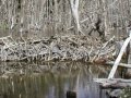 |
Beaver Dam — Those crafty beavers - nature's engineers hard at work! |
 |
Ninja Hiker — Once a promising student, Keith was kicked out of Ninja school for constantly forgetting to remove the big blue water bottle from his backpack. Fortunately, the enemies of the forest are color-blind. |
 |
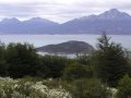
Pampa Alta — Keith at the peak of the Pampa Alta trail, with the Beagle Channel and the mountains of the southern peninsula of Tierra del Fuego in the background. |
